GUSTAFSON1998-001 - archaeological find
Stunner brummer
Akershus (now Nordre Follo), Southeast Norway - Northern Europe
Function not recorded Candidate only
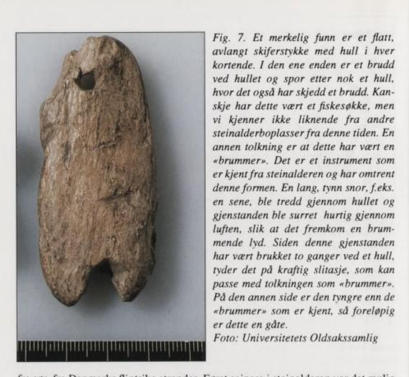
brummer
Source term: «brummer»
brummer: Norwegian 'hummer, buzzer' (brumme, to hum), the standing Scandinavian term for a bullroarer; Gustafson keeps it in quotation marks throughout.
Potato harvesting turned up the first flints at Stunner in 1928, and the Mikkelsen family went on picking the ploughed field until more than seven hundred pieces had reached the Oslo museum from what had once been an island in an Early Mesolithic sea. Among them is a flat slate blade holed at both short ends, broken through one hole and, before that, through an earlier hole at the same end - the kind of damage that comes of hanging something and swinging it hard. Lil Gustafson set out the bullroarer reading in full, cord through the hole and the object whirled until it hums, then weighed the piece against the examples she knew, found it too heavy, and called it an enigma; her own preferred alternative is a fishing sinker. The field it came out of cannot date it, and the ten and a half thousand years belong to the settlement rather than to the stone.
Siden denne gjenstanden har vært brukket to ganger ved et hull, tyder det på kraftig slitasje, som kan passe med tolkningen som «brummer». På den annen side er den tyngre enn de «brummer» som er kjent, så foreløpig er dette en gåte.
Because this object had broken twice at a hole, that indicates heavy wear, which may fit the interpretation as a brummer. On the other hand it is heavier than the known bullroarers, so for the present it remains an enigma.
Gustafson 1998:78, Fig. 7 caption
- Object
- Flat elongated piece of slate with a hole at each short end; at one end the hole is broken through, and traces survive of a further, earlier hole at the same end that had also broken through. No dimensions are published; Fig. 7 carries a millimetre scale, and no measurement is taken from the photograph here.
- Function
- Not recorded.
- Source
- Lil Gustafson, 'Steinalderpionerene på Stunner-øya: Den eldste boplassen i Akershus', Follominne: Jubileumsårbok 1998, pp. 69-80; the object, its mechanics and both readings are given entirely in the Fig. 7 caption, printed p. 78 (PDF p. 80). The site-level chronology on pp. 74-77 rests on Rolf Sørensen's raised-shore curve (162 m level, 9440 +/- 140 BP)…
- Source location
Page references
Follominne 1998, p. 78, Fig. 7 (article pp. 69-80); context and dating pp. 74, 76-77
- Source confidence
- low Ski (Nordre Follo) town-level anchor; Gustafson places the settlement at the 162 m shoreline and about 5 km east of Haugland farm but publishes no site coordinate, and no farm-level position for Nordre Stunner has been verified.