MATHIASSEN1927-001 - archaeological find
Malerualik miniature antler bullroarer
Canada - King William Island (Qikiqtaq) - Kitikmeot, Nunavut - North America - Arctic
Play / practical
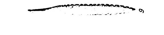
Source term: bull roarer / Svirrer
Svirrer: Danish 'whirrer', the National Museum of Denmark's catalogue term for a bullroarer.
House ruin 13 at Malerualik, on the south coast of King William Island, gave up a sliver of antler less than seven centimetres long and seven millimetres wide — flat, pointed, nicked along both edges, with a small knob at the butt where a cord would be tied. Therkel Mathiassen had no doubt what he was holding: a miniature, a toy version of the bullroarer used across the Inuit world, made small and made carefully. The house supplies only a broad Thule context, roughly AD 1000–1400; the object itself is not dated. Copenhagen still files it under a single Danish word: Svirrer, whirrer.
Pl. 84.9 (P 12.171) is a miniature specimen (toy) of the bull roarer so widely used among natives and many present-day Eskimo tribes; this small, carefully made specimen is of antler and quite flat.
Mathiassen 1927:319
- Object
- Very small, carefully made antler blade, 6.9 x 0.7 cm, quite flat and pointed, notched along the edges, with a small knob at the butt end; Danish National Museum P12.171. Mathiassen calls it a miniature or toy specimen. Neither his text nor Plate 84 fig. 9 records a perforation, so the knob is the only cord attachment described.
- Function
- A toy: Mathiassen publishes it as a miniature specimen of the bull roarer widely used among Eskimo peoples.
- Source
- Mathiassen 1927:319
- Source location
Page references
Mathiassen 1927, printed p. 319 and Plate 84 fig. 9; Nationalmuseet P12.171
- Source confidence
- medium Malerualik River, the official Inuktitut Canadian Geographical Name on the south coast of King William Island (Canadian Geographical Names Database, decision 1961-03-02, 68.55 N / 97.30 W); a place-name anchor for the settlement the site is named after, not a surveyed coordinate for the settlement, house ruin 13, or the object. Mathiassen's own report gives no coordinate; the excavated houses are described as up to 25 m above sea level and roughly 400 m inland.
- Toy / secular survival