No. FOWLER1979-001
Kaibab Southern Paiute notched whirrers
United States · Arizona Strip · Kaibab Indian Reservation, northern Arizona · North America · Great Basin
Weather / fertility magic
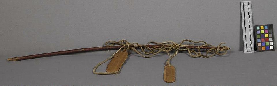
naiyaratinömpö
Source term: bullroarer
naiyaratinömpö: the Kaibab word for the bull-roarer.
Powell's collection preserves a strange compound roarer: a long sumac staff, sinew cord and buckskin thong carrying two small notched wooden whirrers — an elaborate three-part rig gathered while the one-armed major was mapping the canyon country of the Colorado. What the Kaibab used the bull-roarer for was set down some sixty years on, when Mose, a blind Kaibab elder at Moccasin, Arizona, described the naiyaratinömpö to Omer Stewart: a wooden blade on a handled string, a boy's toy — and a means of making the wind blow. Powell's catalogue credits the rig to the Kaibab, whose name he himself carried onto the map: Southern Paiute for 'mountain lying down.'
There is a single bullroarer in the collection.
Fowler and Matley, Material Culture of the Numa (1979), p. 72.
Particulars
- Object
- A 67.5 cm Rhus trilobata stick, 76 cm four-ply sinew cord, and 69 cm buckskin thong carry two three-notched wooden whirrers (9 x 4 cm and 7 x 3 cm).
- Function
- This specimen's use is unrecorded; among the Kaibab the bull-roarer was a toy and was whirled to make the wind blow.
Source
Don D. Fowler and John F. Matley, Material Culture of the Numa (Smithsonian, 1979), p. 72, fig. 62a and table 2 (USNM 10773/1); Omer C. Stewart, 'Culture Element Distributions: XVIII, Ute-Southern Paiute,' Anthropological Records 6(4) (1942), Kaibab list, p. 239