No. LOEB1929-040
Kulisehu River toy bullroarer and sacred flute
Brazil · Upper Xingu · Kulisehu River · South America
Play / practical
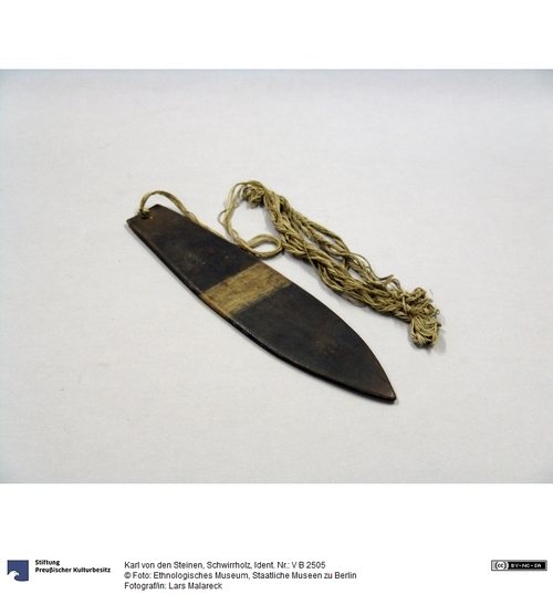
yelo
Source term: yelo / iyelo (Bakairí)
thunder/thunderstorm (Bakairí); cf. Mehinakú matápu, Nahuquá matáhu
Etymology. For the Bakairí the bullroarer is yelo (iyelo), the same word for "lightning and thunder" — best rendered, von den Steinen says, as "thunder" for the sound it imitates. The Mehinakú (matápu) and Nahuquá (matáhu) share what he treats as the same word.
On the Kulisehu River in the Upper Xingu, the bullroarer was a child's plaything, and the flute, not the bullroarer, was the sacred instrument. Edwin Loeb set the detail against its neighbor for contrast: among the Bororo nearby, von den Steinen had reported that women sought refuge in the woods the moment a bullroarer was sounded, and would have died had they seen one. Here the roles were reversed, and the whirring board passed into the hands of children.
Wir werden ihm bei den Bororó und zwar auch in einer geheimnissvollen Bedeutung, die am Kulisehu fehlt, wieder begegnen …
We shall meet it again among the Bororó, and there, indeed, in a mysterious significance that is lacking on the Kulisehu …
Karl von den Steinen, Unter den Naturvölkern Zentral-Brasiliens (1894), p. 327
Particulars
- Function
- Used as a toy.
Source
Edwin M. Loeb, Tribal Initiations and Secret Societies, University of California Publications in American Archaeology and Ethnology 25(3) (1929): 249-288, p. 281; Karl von den Steinen, Unter den Naturvölkern Zentral-Brasiliens (Berlin: D. Reimer, 1894), pp. 327-328